
3D Cadastre GIS – Survey of Israel
Project Name: 3D Cadastre GIS
Client: Survey of Israel
Country: Israel
![]() 3D Cadastre is an exciting, new and highly interesting topic for land administrations all over the world. It is also a high profile issue in Israel, and the Survey of Israel (SOI) is promoting the issue for several years.
3D Cadastre is an exciting, new and highly interesting topic for land administrations all over the world. It is also a high profile issue in Israel, and the Survey of Israel (SOI) is promoting the issue for several years.
At the beginning of 2008 Sivan Design, a leader in the field of GIS, land registration, CAD and 3D simulation software solutions, had joined forces with SOI in order to design the 3D cadastre integration into the current Cadastre GIS in SOI.
3D Cadastre GIS Project Objectives
The project included many activities and services all of which were provided by Sivan Design:
- Main objective examine the requirements and the design of a GIS system that support 3D cadastre
- Considerations: data structure, layers, processes, topology and visualization
- Software PLAGIS Software development and adaptation according to Ministry’s needs
- Existing GIS platforms do not fully support a 3D cadastre
- Open issues are complex and interdisciplinary
“Examine the requirements and the design of a GIS system that support 3D cadastre”
Visualizing 3D GIS Cadastre
A 3D enviornment includes many entities in addition to a full terrain visualization. There are few challenges when trying to achieve high quality visualization. One of the greatest challenges is to reach reasonable performance despite the enormous amount of data needed to achieve accuracy. Another challenge is the integration of human made objects with the landscape.
Recognizing a bridge in Google Earth from a high point of view is easy, but as the camera gets closer (see the zoom on bridge image), it is not as clear. It is not just the quality of the picture but also the lack of specific modeling of the bridge and neighboring surfaces.
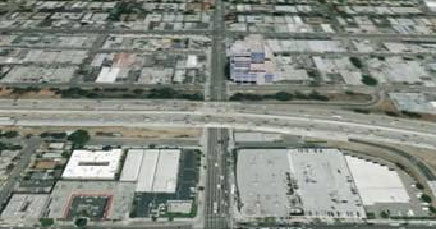
Bridge view (© Google Earth)
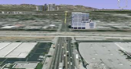
Zoom on bridge (© Google Earth)
Another way is to use different level of details for different parts of the displayed image (LOD). Usually “closer” areas are described in maximum details and remote areas with less (details = points and triangles).
The way the system store and present data also affect the way is can analyze that data. Measurements, line of sight, collisions between entities, etc, are complex queries in a 3D environment that can be easier to present and review with the right 3D modeling.
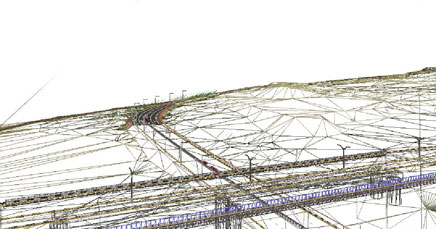
Terrain and bridge – triangulation (© Sivan Design)
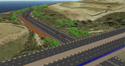
Terrain and bridge (© Sivan Design)
A solution for modeling combined surfaces by Sivan Design
- Pictures taken from Civil Simulate
- Creation of holes in topography to avoid surface overlapping and with it surface visibility problems
Summary
- The future cadastre in Israel will be analytical, three-dimensional (3D), multilayer and will be incorporated into the national GIS system and will be managed by GIS means
- The spatial registration will be achieved by sub-dividing the surface parcel space into spatial sub-parcels
- Necessary amendments will be made in the relevant laws and the Survey Regulations